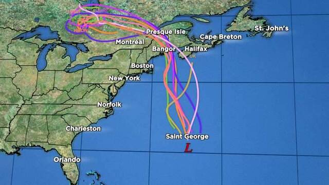
| Location | 110 miles S of Bermuda |
| Wind | 50 mph |
| Heading | NNE at 16 mph |
| Pressure | 29.62 |
| Coordinates | 64.6W, 30.7N |
Recommended Videos
Discussion
At 1100 AM AST (1500 UTC), the center of Post-Tropical Cyclone Philippe was located near latitude 30.7 North, longitude 64.6 West. The post-tropical cyclone is moving toward the north-northeast near 16 mph (26 km/h). A northward or north-northwestward motion at a faster forward speed is expected during the next few days. On the forecast track, the system will continue passing Bermuda today and will reach the coast of Atlantic Canada or eastern New England Saturday night or Sunday.
Maximum sustained winds are near 50 mph (85 km/h) with higher gusts. Some strengthening is possible over the next day or so.
Tropical-storm-force winds extend outward up to 205 miles (335 km) to the east of the center.
The estimated minimum central pressure is 1003 mb (29.62 inches).
Watches and Warnings
CHANGES WITH THIS ADVISORY:
The Bermuda Weather Service has discontinued the Tropical Storm Warning for Bermuda.
SUMMARY OF WATCHES AND WARNINGS IN EFFECT:
There are no coastal watches or warnings in effect.
Interests in eastern New England and Atlantic Canada should monitor the progress of the post-tropical cyclone and refer to products issued by their local weather offices.

Land Hazards
Key messages for Philippe can be found in the Tropical Cyclone Discussion under AWIPS header MIATCDAT2 and WMO header WTNT42 KNHC and on the web at hurricanes.gov/text/MIATCDAT2.shtml
WIND: Strong winds are possible over portions of Atlantic Canada and eastern New England this weekend.
RAINFALL: Rainfall will be diminishing across Bermuda today. An additional inch or less of rainfall is possible.
For portions of New York and New England, and Southeast Canada, rainfall amounts of 1 to 3 inches, with local maximum amounts of 5 inches, are expected this weekend. Isolated to scattered instances of urban and flash flooding will be possible.
SURF: Large swells will continue to affect Bermuda for the next few days. Swells are also affecting portions of the southeastern U.S. Coast and will spread northward along the east coast to Atlantic Canada during the next couple of days. These conditions are likely to cause life-threatening surf and rip currents. Please consult products from your local weather office.